


Democratic Republic of Congo
Congo gained independence from Belgium in 1960. From 1971 to 1997 the country was officially the Republic of Zaire, a change made by then ruler Gen. Mobutu Sese Seko to give the country what he thought was a more authentic African name. “Zaire” is a variation of a term meaning “great river” in local African languages; like the country’s current name, it refers to the Congo River, which drains a large basin that lies mostly in the republic. Unlike Zaire, however, the name Congo has origins in the colonial period, when Europeans identified the river with the kingdom of the Kongo people, who live near its mouth. Following the overthrow of Mobutu in 1997, the country’s name prior to 1971, the Democratic Republic of the Congo, was reinstated. Congo subsequently was plunged into a devastating civil war; the conflict officially ended in 2003, although fighting continued in the eastern part of the country..


Congo is rich in natural resources. It boasts vast deposits of industrial diamonds, cobalt, and copper; one of the largest forest reserves in Africa; and about half of the hydroelectric potential of the continent.
Land
Congo is bounded to the north by the Central African Republic and South Sudan; to the east by Uganda, Rwanda, Burundi, and Tanzania; to the southeast by Zambia; and to the southwest by Angola. To the west are the country’s short Atlantic coastline, the Angolan exclave of Cabinda, and Congo (Brazzaville).
Good to Know
Country
Democratic Republic of Congo
Visa Requirements
Everyone needs a visa.
French, Swahili
Democratic Republic of Congo
Franc Congolais
Democratic Republic of Congoo (RDC)
Area (km2)
2,345,409 km2
Relief
The country’s major topographical features include a large river basin, a major valley, high plateaus, three mountain ranges, and a low coastal plain. Most of the country is composed of the central Congo basin, a vast rolling plain with an average elevation of about 1,700 feet (520 metres) above sea level. The lowest point of 1,109 feet (338 metres) occurs at Lake Mai-Ndombe (formerly Lake Leopold II), and the highest point of 2,296 feet (700 metres) is reached in the hills of Mobayi-Mbongo and Zongo in the north. The basin may once have been an inland sea whose only vestiges are Lakes Tumba and Mai-Ndombe in the west-central region.
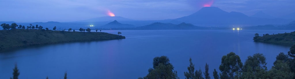
The north-south Western Rift Valley, the western arm of the East African Rift System, forms the country’s eastern border and includes Lakes Albert, Edward, Kivu, Tanganyika, and Mweru. This part of the country is the highest and most rugged, with striking chains of mountains. The Mitumba Mountains stretch along the Western Rift Valley, rising to an elevation of 9,800 feet (2,990 metres). The snow-covered peaks of the Ruwenzori Range between Lakes Albert and Edward lie astride the Ugandan border and mark the country’s highest elevation of 16,763 feet (5,109 metres) at Margherita Peak. The volcanic Virunga Mountains stretch across the Western Rift Valley north of Lake Kivu.
.
Cultural life
Holidays celebrated in Congo include Commemoration of the Martyrs of Independence, observed on January 4; Labour Day and National Liberation Day, celebrated on May 1 and May 17, respectively; Independence Day, celebrated on June 30; Parents’ Day, celebrated on August 1; Youth Day, observed on October 14; Army Day and the Anniversary of the Second Republic, observed on November 17 and November 24, respectively; and Christmas, celebrated on December 25.


